Νομός: Χανίων

Μέρη κοντινά με Εθνικός Δρυμός Σαμαριάς
Samaria or the Samaria Gorge is one of the main sights of Crete. Every tourist who visits Crete will have heard of this beautiful gorge or soon will.
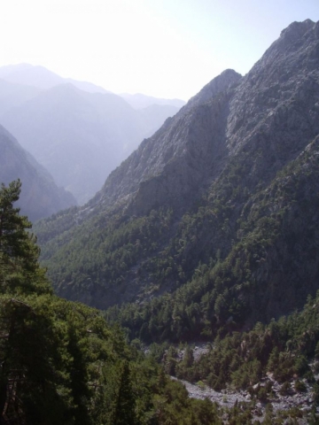
Samaria Gorge is found in the White Mountains of south-west Crete in the district of Chania. They are called the White Mountains because the sun shining on the limestone rock of their peaks make them appear that colour.The capital of the district of Chania is the town of that name. It`s a very popular tourist destination on the north coast of the island. If you look at a map of Crete you will find the Samaria gorge directly south of the town but on the opposite coast.The White Mountains contain over forty gorges of various sizes. The best known are Imbros Gorge, The Gorge of Agia Irini and the Samaria Gorge which is definitely the most famous of them all. Even though these gorges are all to be found on the same part of the island of Crete, they all have different characteristics.Samaria Gorge is named after a village of that name which is found about halfway down the gorge. The village in turn gets its name from a small 14th century church sited close by. This is the church of the Holy Mary, in the Greek language, "Osia Maria." So it is easy to see where the name Samaria comes from!The village has been deserted since 1962. The last inhabitants had to leave when the whole area was designated as a National Park. Although many of the old houses still remain, they only act as accommodation for the Park wardens. The old church of Osia Maria is still there, a little way out of the village.All the gorges in the Crete Mountains in Chania were formed by the same geological process. Water ate away the soft limestone rocks over thousands of years after the land had been uplifted by seismic activity. This water erosion has also led to huge numbers of caves being formed. There are as many as 3,000 over the island. A lot of these caves are archaeologically and religiously significant. Over a 100 of the caves have churches in them.The Samaria Gorge starts near the small town of Xyloskalo on a level area in the White Mountains called the Omalos Plateau. The name Xyloskalo can be translated as "wooden stairway." This is because the locals had built just that thing to help them enter down the steep opening into the gorge.The Omalos Plateau is over 1,200 feet above sea level and the gorge runs in a southerly direction from there down to the south coast of Crete near the village of Agia Roumeli.Of all the things to do in Crete visiting the Gorge of Samaria is a must for many tourists, especially those on Crete walking holidays. Mnay Crete excursions are based around this great hike.Coaches will collect you early in the morning and take you to your starting point at Xyloskalo in the Crete mountains. Once you have completed the hike and reached Agia Roumeli on the coast, you catch a ferry boat to the nearby port of Hora Sfakion where your coach will collect you once more.The locals call the gorge "Farangas" which means "great gorge." They also like to claim that it is the longest gorge in Europe, but that is debatable.What is certain is that in some places it can definitely be counted amongst the narrowest!The most dramitic part is a a place known as "Sideroportes" or the "Iron Gates." Here the Samaria gorge is so narrow, being about four metres wide, that you feel as though you can reach out and touch both walls at the same time.If you look up at the cliffs, which rise almost vertically above you for 350 metres, you feel totally overawed!The journey down the gorge, from Xyloskalo to Agia Roumeli on the coast, is about 18 kilometres and although the hike is not an easy one, it is extremly beautiful. The path follows a clear stream which goes through heavily scented pine forests of tall Cypress trees. There are many olive trees and some small fields with low stone walls.The Samaria Gorge is only open to visitors between the beginning of May and the middle of October. There a charge for entering the gorge, at the moment it is 5 Euros. This goes towards the maintenance of the National Park. You must keep your ticket and hand it to the warden as you leave the park, this ensures that no-one is left in the gorge overnight.During the winter months you are unable to go down the gorge.This ban can even occur in the summer season if there has been rain. This is because the pretty stream you cross many times on your hike down the gorge can turn into a raging torrent. Rain or melting snow in the Crete mountains can raise the height of the water considerably.In fact the Village of Agia Roumeli, at the bottom of the gorge, was badly flooded in the 1950`s. There are still some ruined houses which are only now being rebuilt.High winds can also cause problems. Although you may not be aware of them when you are down in the gorge they have been known to cause stones to fall from the 350 metre high cliffs. In fact there are signs warning of this danger.Any walk down the gorge usually becomes a competition to spot the rare Kri-Kri.This is a Cretan Wild Ibex with distinctive curved horns. It was introduced into Samaria gorge as a refuge for it. In fact this is only one of two places it is to be found.If you are very lucky you may spot some rare birds such as the Griffon Vulture, Bonelli`s Eagle and the Golden Eagle.One thing about Samaria Gorge you should be aware of is its popularity. During the tourist season there will be lots of people hiking through it every day.The beauty and dramatic quality of Samaria Gorge make it one of the most popular gorges to visit in the world.
Tarra is mentioned by many ancient writers as a small but strong and independent town. It used to have its own currency coins on one side depicting the Cretan mountain goat and an arrow and on the other side a bee.
Agia Roumeli is a very special and unique place with its genuine cretan background. It has strong character and soul surrounded by breath taking, wild mountains and a long beach of fine pebble by the clear Libyan sea. In Agia Roumeli and its surroundings you can relax, you can switch off the outside world. You almost forget it exists. Here you can watch all the stars, the galaxies. The natural geographical position of Agia Roumeli aids this tranquil sensation.
At the present on the beach, there are hotels, rooms for rent and taverns. Best time to visit Agia Roumeli is in the summer months. The season extends from April to October when the temperature range is from 25-38 degrees. Agia Roumeli is connected with Sfakia, Loutro & Sougia, Paleochora only by ship, from where you can return to Chania. If you do not wish to cross all of the distance of Samaria gorge to approach Agia Roumeli, you can do it by sea by motorboat.
The coastal path from Agia Roumeli village to Agios Pavlos beach (east) leads further to Agios Ioannis village and Marmara-Loutro area.
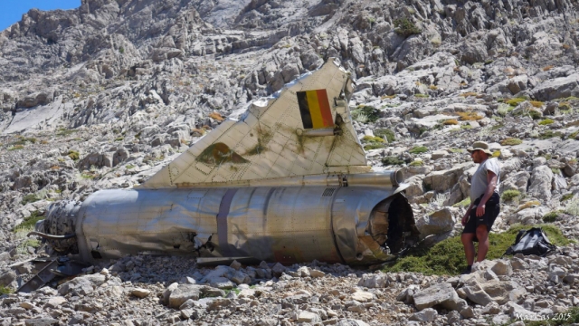
Σε άσκηση του ΝΑΤΟ, που συμμετείχαν και βελγικά αεριωθούμενα πολεμικά αεροσκάφη δύο από αυτά ´έμειναν´ για πάντα στα Λευκά Ορη, αφού το ένα προσέκρουσε στην κορυφή Καλόρος, υψόμετρο 1.925 μέτρα, όπου τα συντρίμμια του είναι διασκορπισμένα σε μεγάλη έκταση και το άλλο, μάλλον επιχείρησε ανώμαλη προσγείωση στους Ποταμούς, στην περιοχή Αη Γιάννη Σφακίων, όπου ευρίσκεται ακόμη η άτρακτός του.
On the right hand side of the road descending from the Omalos plateau to Chania, there is the large canyon-cave called Honos or the Cave of Tzanis, which served as the den of the chieftain Tzanis Markos during the first years of the Turkish invasion.
Nicknamed ‘Fovos’ (fear), he struck terror into the hearts of the invaders. The cave was explored for the first time by speleologists from Chania and France. It is 2.5 kms in length, and the height of the cavern is 241 metres; it forms a huge covered gorge.
Opposite the entrance of the cave of Tzanis, on a small knoll, there is the Tower and chapel of the famous rebel chieftain from Lakki and hero of the Lefka Ori, Hadzimihalis Yiannaris (1851-1916). One of the pioneers in the uprisings of 1855 and 1856 and a major contributor to the great uprising of 1866-1869, he was imprisoned many times by the Turks but always managed to escape. On one occasion, about to attempt the almost impossible escape from the fortress of Firkas in Chania in 1860, he vowed that if successful he would build the small chapel of Agios Panteleimon in Omalos next to the Tower. He kept the vow and, honoured as a general, was buried there according to his own wishes, in his old "lair". Great both in stature and soul, he served as a general leader of the district of Kydonia in Chania from 1866 to 1898.
The last part also of the gorge and the coast area are called Domata. The most beautiful and cleanest coast in Crete is situated there, with a sea of wonderful colours, covered by a very thin and shiny boil, and the pine trees of the gorge reaching out to the coast.
The route from Sougia to Agia Roumeli is reasonably well waymarked with E4 signs and cairns, but is a difficult 1 or 2-day walk (total 12 hours), and water can be a problem. March and April is maybe the best season and not too hot, and there is water at the bottom of Tripiti Gorge. Stay overnight on Domata beach, then early next morning move over to Agia Roumeli (about 4hrs - difficult walk)
Sougia - Tripiti Gorge-beach 4,5 hours
Tripiti - Domata beach 3 hours
Domata beach - Agia Roumeli village 4,5 hours
It was built in 1994. Christos Houliopoulos, the then president of the mountaineering club, led the building works and the shelter is named after him. It is worth mentioning that the greater part of the building materials had to be brought by helicopter to this location. It is about 6-7 hours hiking away from the Kallergi shelter, and from Rousies where the dirt road from Anopoli village ends, it is about 3 hours away. The shelter can accommodate 20 climbers.
Αγιά Ρουμέλη. Παραλιακό χωριό που ευρίσκεται στην έξοδο του φαραγγιού της Σαμαριάς.
Η λέξη προέρχεται από τους Άραβες και έχει την έννοια Ελληνικά νερά ή Ρωμαίικα νερά. Το χωριό είναι κτισμένο κοντά στην αρχαία πόλη Τάρρα.
Αποτελεί δημοτικό διαμέρισμα μαζί με την Παλαιά Αγία Ρουμέλη και έχει 125 κατοίκους(2001).
Πέτρινο μονότοξο γεφύρι το οποίο βρίσκεται στην έξοδο του Φαραγγιού της Σαμαριάς.
Immediately after the beautiful beach of Kalogeros (800m west of Agia Roumeli) and after 500m you find Fournoti beach, a well-secluded beach, which stands out for the cave in the center. The area is accessible only by boat. The beach area is protected by the Bern Convention, since this sprout yellow flowers (Hypericum aciferum). Here you will find a unique two-storey cave-shaped "A".
Hiking from Agia Roumeli to Sougia
The route from Sougia to Agia Roumeli is reasonably well waymarked with E4 signs and cairns, but is a difficult 1 or 2-day walk (total 12 hours), and water can be a problem. March and April is maybe the best season and not too hot, and there is water at the bottom of Tripiti Gorge. Stay overnight on Domata beach, then early next morning move over to Agia Roumeli (about 4hrs - difficult walk)
Sougia - Tripiti Gorge-beach 4,5 hours
Tripiti - Domata beach 3 hours
Domata beach - Agia Roumeli village 4,5 hours
A small mountainous ancient city, built inside Samaria gorge near the banks of the river. The city developed in the ancient years and according to tradition it was the birthplace of Artemis the Britomartis, called Diktini, who was the daughter of Zeus.
In 1991, they found an outdoor sanctuary near the church of Agios Nikolaos as well as many bronze and iron, arrows and spears. That was probably the oracle of Apollo or else, the Kirikion Andron. It is said that the nymph Akakali, wife of Hermes and daughter of Minos was worshipped there.
Tarra or Tarrha was an ancient city of western Crete, near Samaria Gorge, at Agia Roumeli village. It is near the sea, on the hill, on the left bank of the stream bank. It was probably established in the Classical period and was very important religious centre. The city flourished in the Greco-Roman period. There was the cult of Apollo Tarraios. There were found parts of his temple. Tarra in frequently cited in the ancient sources. Although it was small town, Tarra had its own coins. The coins have the head of Cretan wild goat, arrow, and bee. Tarra had monetary union with Elyros, Yrtakina and Lissos. The coins belong to the 3rd and 2nd century BC, when Tarra became member of the Republic of Cretans. The city had established a colony of the same name in the Caucasus. It is also believed that Tarra of South Italy was another colony of the city. It probably founded Lampa, also on Crete.In 1415, Buondelmonti detected in the ruins of the Temple of Apollo, an inscription in Greek that was saying: “Peel your shoes, cover your head and come in.” A similar inscription was found at the Temple of Matala. The custom of entering the temple without shoes is ancient. Apollo, after the murder of Python, went to Tarra, where there were done purgatorial rituals by priest Karmanoras. According to Pausanias, Apollo “in the house of Karmanor, Apollo made love with nymph Akakallidi”. The nymph gave birth to twins, Phylakides, and Philanders. A goat fed them. Therefore, the Elyrians presented to Delphi bronze goat feeding to infants. In Tarra, there were glassworks workshops.It was the birthplace of the author Lucillus of Tarrha or Loukillos. He commented on the Argonautics by Apollonios of Rhodes. Chrysothemis, a lyre player, son of Karmanor, who won at the Pythian festival, was from Tarra as well. Tarra is one of the city that signed decree with Eumenes B’ in 170 BC. Robert Pashley was the first who detected the location of the city. In the area, there was found stone stele with inscribed double axe. It is exhibited at the Archaeological Museum of Chania.
Drakoulaki Cave is located close to Agios Ioannis village at south Lefka Ori, Sfakia region, west Crete. A small opening at the root of a cliff leads to a whole different world in the bowels of the earth.
The sand, the stalagmite designs, the small transparent lakes and the absolute silence that prevails, create a memorable experience. The first 400 meters are compatible for everyone but from there, the descent can be done only by experienced cavers. The Drakoulaki Cave is located northeast of Agios Ioannis and the path leading there is about two and a half hours.


