Νομός: Χανίων

Μέρη κοντινά με Κωστογιάννηδες
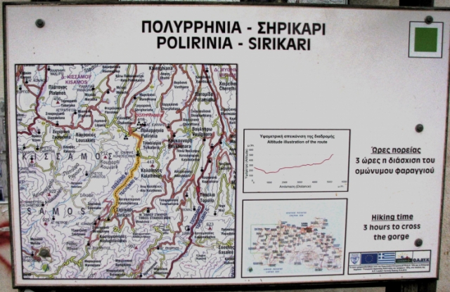
Sirikari or Tsihlliano gorge
The village of Polirinia is situated 7 kilometers south of the town of Kissamos in the west of Crete. You can reach it by driving to and through Kissamos.
If you want an extra walk in the area it is also possible to walk up the gorge of Sirikari (or Tsihliana gorge) from Polyrinia. You have two options:
1. Walk down from the centre of the village until you reach a road below which you will follow for about 2 km. I won’t be more precise because there are several routes from the village centre to the road. Once on the road follow the directions below.
2. Drive back out of the village for 100 m until you see a sign for Cemetery of ancient Polyrinia. Drive down this road, descending into the valley. After around 1.5km the road will cross the valley to the left (it’s a small riverbed). Do not follow the main road but bear on your right (so stay on the right side of the valley) and follow and older unpaved track. It will take you to a fence which you will need to cross in order to get to the path to the gorge. There is a sharp right turn at this point. If you follow this for 50 metres (going steeply up) you will be able to park your car by a chapel.Cross the fenced area, past an electric transformer and after 200 m cross an ancient bridge and this is the start of the walk. It is clearly marked. You can go as far as you want but considering that you will need to walk back I suggest walking for an hour to 90 minutes then turning back. This should will cover the lower part of the gorge which is the most spectacular. If you want to carry on to the end it will take you about 2 hours to reach the road near the church of Agios Konstantinos, not far from the village of Sirikari.
Sirikari (53 inhabitants) is located 52 km away from Hania city, Chania Prefecture, West Crete and 14 km from Kastelli or Kissamos at 500m a.s.l. Its is the seat of the municipality of the same name which consists of the villages : Katsikantiana (20) , Kioliana (32), Kontokrithiana (15), Kostogiannido (31), Megalo Horio (62), Miheliana (10), Stratigiana (20), Siniana (54), Tzortziana (4) and Tsihliana (13).
The nature of Kissamos is presented here in all its magnitude. Tree covered mountains and deep ravines, form a landscape of unique beauty. People who preserve their old customs, gentle, brave and hospitable. Sirikari is the birth place of Theodoros Baxevanis, a hero who was killed in 1867 fighting the Turks.The name Sirikari probably comes from the profession of the first settler, who has to be a silk weaver (Sirikaris).Trekking paths : To Polirinia, Vlatos and KambosSights : The Sirikari-Plorinia gorge, the chesnut tree forest, the cave of the Holy Mother (Panagias), the byzantine church of Agii Apostoli with frescoes of 14th century a monument of great importance and two old factories.
Sirikari, well known because of its sweet chestnut and walnut trees. Also a place, where “foxes and rabbits says goodnight to each other”. There you can have a walk underneath high trees and enjoy the nature.
The one and only kafenio in Sirikari offers coffee and beer also like some food. The walk goes from there through the gorge of Sirikari up to Polirinia.
It is an experimental park with 150 species of plants, covers an area of 1,000,000 sq.m. and is part of an extended area of 20 sq.km. which have been reforested.
Visitors can follow a footpath through it, or hike through the forest to the top of the mountain and to Plakia.
The "Park of Peace" was founded in 1970 by the Cultural Association of Vlatos with the cooparation of Goethe Institute and the support of the Bavarian Department of Forests. It is an experimental park with 150 species of plants, covers an area of 1,000,000 sq.m. and is part of an extended area of 20 sq.km. which have been reforested.


