
Your Position:
Unknown


Γούδουρας
Νομός: Λασιθίου
Προτείνετε
Η γνώμη σας

Αν θέλετε να μας πείτε την άποψη σας γι αυτήν την τοποθεσία, θα σας παρακαλούσαμε να γράψετε ένα σχόλιο.
Σχολιάστε:

Γούδουρας
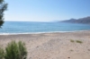
Goudouras is a well-known fishing village on the Libyan Sea, close to the well known Kapsa Monastery and Pervolakia gorge. It is situated 12 km to the east of Makrigialos in a unique setting with clean waters and beaches.
As well as earning money from fishing and tourism, the local inhabitants have increased their income from the cultivation of out-of-season produce and hot house fruit and vegetables.
Μέρη κοντινά με Γούδουρας

The name Asprolithos (white stones) derives from the white pebbles which can be found at the beach. Asprolithos beach is a picturesque sand and pebble beach in the southeast coast of Crete in between Kalo Nero (which means “Good Water”) settlement and very close to Goudouras village, 12km east of the tourist resort of Makrigialos and close to the Kapsa Monastery.
The nearby coastal village of Goudouras is a center for agriculture and you will see many greenhouses that are covered with plastic. There are no facilities like umbrellas and sunbeds on the beach of Asprolithos, there is just sand and seawater.
It’s a quiet beach although it is located just next the asphalt road. The problem with the beach is that there can be quite some wind here. In 2008 as we drove by, after a couple of stormy days it looked as if a large part of the beach had disappeared.


Φαράγγια στη περιοχή Γούδουρα
Μικρά σε μήκος μέχρι 1,5 χιλιόμετρα, αλλά από τα ποιο δύσβατα της περιοχής που απαιτεί αυξημένη γνώση και εμπειρία από τον περιπατητή και σε πολλές περιπτώσεις χρήση ειδικού εξοπλισμού.
Όμως τα σπηλαιώδη κάθετα βράχια τους δημιουργούν τέλεια καταφύγια για την ορνιθοπανίδα και πολλα σπάνια ενδημικά φυτά βρίσκουν καταφύγιο στα απότομα βράχια των φαραγγιών αυτών. Είναι του Αγίου Αντωνίου που πήρε το όνομα του από την μικρή εκλησία στη βόρεια είσοδο του φαραγγιού το οποίο καταλήγει στο χωριό Γούδουρας, το φαράγγι που ξεκινά από το χωριό Μέσα Απίδι και σε κάποιο σημείο της διαδρομής του συναντά μια δεύτερη διακλάδωση από τον εγκαταλελειμμένο οικισμού Σαμακίδι και καταλήγει βόρεια του Γούδουρα και το φαράγγι του Ασπρόλιθου, μικρό δύσβατο φαράγγι που καταλήγει βορειοδυτικά του χωριού Γούδουρα
http://biodiversitysitia.gr/


Goudouras village, is a coastal settlement with approximately 300 permanent residents near the Cape of Erithreo at the Libyan Sea, Lassithi Prefecture and 16km east from Makrigialos.
It is developing slowly to a sea resort, there are some remarkable sandy beaches like Kalami, Asprolithos and Goudouras beach, and you can find also taverns, lodgings and a small shelter for fishing boats.
It is a farming community / vegetable store situated on a fertile plain directly at the sea, with lots of greenhouses and a couple of farms and houses. Behind the village there are the Zakros-Ziros mountains and the area becomes quite deserted. In Goudouras the road turns north towards the traditional villages of Agia Triada, Ziros and the beaches of Xerokampos and Kato Zakros.

