
Your Position:
Unknown
Λεπτομέρειες ΕικόναςImage details
More Photos


Press here.


Analipsi
Prefecture: Lassithi
, Suggest
, Suggest
Your Opinion

If you want to tell us your opinion about this place, please leave a comment
Post a Comment:

Analipsi
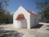
Στη θέση Ασπροπηλιά σε ένα χαμηλό αλλά εξέχοντα λόφο βρίσκεται ο μικρός καμαροσκέπαστος ναός που είναι αφιερωμένος στην Ανάληψη του Σωτήρα Χριστού. Ο ναός οικοδομήθηκε στο διάστημα 1960-1962, σύμφωνα με την απόφαση που έλαβε το Εκκλησιαστικό Συμβούλιο της Μυρσίνης το 1960 (πράξη 5/21-3-60) ικανοποιώντας την παλιά επιθυμία του ιερέα της Μυρσίνης Μιχ. Ζερβάκη. Το χώρο παραχώρησε η Πιπίνα σύζυγος Γ. Καραγιαννάκη και το σχέδιο εκπόνησε ο μηχανικός Νίκος Βουράκης. Τα εγκαίνια του ναού έγιναν το 1962. Οι εικόνες που κοσμούν το εσωτερικό είναι έργα του ζωγράφου Σαριδάκη.
Κάθε χρόνο την ημέρα της Αναλήψεως (την Πέμπτη, σαράντα ημέρες μετά το Πάσχα), μετά τη Θ. Λειτουργία γίνεται μεγάλο πανηγύρι στο προαύλιο του ναού με βιολιά, χορούς και φαγητό.
Στην Ασπροπηλιά, πολύ πριν φτιαχτεί ο ναός, υπήρχαν μερικά σπίτια - μετόχια που είναι και σήμερα ορατά γύρω από το λόφο. Σε αυτά φαίνεται πως ζούσαν απομονωμένοι οι άνθρωποι που έπασχαν από λοιμώδεις ασθένειες. Για κάποιον από αυτούς είναι γνωστό ότι τάφηκε στο γειτονικό ναό του Αγίου Δημητρίου.
Η τοποθεσία Ασπροπηλιά είναι ακόμα γνωστή για το μινωικό νεκροταφείο που ανασκάφηκε τη δεκαετία του 1960 φέρνοντας στο φως πλούσια ευρήματα.
Places near Analipsi

This village on the main Sitia - Agios Nikolaos road is 25 kms from the former one. It used to be called Metochia tis Tourlotis (i.e. hamlets belonging to Tourloti).
The name Mirsini means «myrtle» and there are indeed many myrtle bushes growing there. In the Venetian census of 1583 no village is listed under the old name. Ρ. Faure who has done a lot of research on place-names in Eastern Crete, states in his study «Villes et villages de la Crete Orientale» that he believes the place marked as Cathia by F. Basilicata on his map of Crete in 1629, must be Mirsini.
We do not know however, what foundation Faure used for his identification. Tombs of the Last Μinoan period were found at Halinomouri; finds from them include vessels, weapons and utensils. At the location called Kastellos or Lenika there was an ancient town, andat Avgo a LateMinoan guard-station.
In 1959 Ν. Platon (then Ephor of Antiquites) excavated a cemetery of the LateMinoan period with chamber tombs in the vicinity of the hill Asprospilia. At Galana Harakia acircular communal tomb (the Messara type) of the Minoan era was found. It was the first of this type to be discovered in Eastern Crete and contained over 60 burials. Vessels of the Εarly Μinoan and Μiddle Μinoan periods were found and also 25 Larnakes and pithi. In the chapel of Ayios Antonios, the date 1677 and the name Vintzetzos Kornaros have been scratched onto the wall.
Mirsini Village in East Crete Mirsini Village in East Crete
Xanthoudides regarded this Kornaros as being the poet of «Erotokritos», but the most recent study rejects this belief. (See Sitia). The Kornaros family must have been, in anycase, connected witn this district, as a small tower outside the village is still called the Kornaros tower.
From the book "Sitia", N.Papadakis, Arcaeologist,1983


The church of Agios Antonios and its accompanying medieval tower are in the region of Mirsini village (6km north from the village), 25km west of Sitia Town, in a location not far from the sea, where there was a small settlement for many years.
The construction of the original church of St. Antonios dates back to Byzantine times. The church seems to have been filled with frescoes depicting saints and scenes from the gospel. With the collapse of the tower in 1918, the church was largely shattered but shortly afterwards rebuilt in its current form in 1920. On the northern wall inside the church survives the etching ‘Vitzentzo Kornaros 1677’. The pilgrim who wanted to leave a note of his visit to the church is not the poet of Erotokritos, but rather one of the descendants of the localized Greek-Venetian noble family.
The construction of the tower dates back to the Venetian rule. It is possible that it had been built as a fortified tower-house, something which was common after the 15th century for noble families who lived in the countryside. Simultaneously, it may have been built so as to guard the area, because of the frequent pirate and Turkish raids. During the revolt against the Ottomans in 1897, the locals feared that the Turks would take and exploit the tower to their benefit, so they tried to destroy it using dynamite. The tower suffered severe fractures and a large part collapsed during a great storm in 1918. During the 1990s the tower was restored and has been open to visitors since then.


