



Your Position:
Unknown
Λεπτομέρειες ΕικόναςImage details
More Photos
 Upload your photos for Panagia and share them with us!
 Press here.


 Address:
Μακρύς Γιαλός 720 55, Ελλάδα
Address:
Μακρύς Γιαλός 720 55, Ελλάδα  Telephone:




Places near Panagia

This village on the road to Stavrohori is about 25 km from Sitia (South West) .
It is divided into two groups of houses called Apano Kria and Kato Kria. In the Venetian census of 1583 it was listed as Cria with 176 inhabitants.
The local people pronounce the name «Kriya» and insist that as it gets very cold there in the winter months the name of the village reflects the climate, (krio: cold), and it seems quite likely that this is the true origin of the name. Above Kato Kria, on the hill called Trapeza, traces of ancient ruins are to be found. Near the village, on the hill of Agios Georgios, next to the chapel after which the hill has been named, are the remains of Late-Roman water cisterns. The top of this hill is surrounded by the walls of a Venetian fortress known as Monte Forte. The Venetians must have built it in the 13th or 14th century ΑD for the protection of the lahds they had seized. It is contemporary with the forts of Sitia, Liopetro, Agios Stephanos and Voila.
Ιn 1971 eχcavations were started on a group of graves at Tsachali, a deserted spot on the lower slopes of the hill; the dig was completed in 1977. It proved to be a cemetery of the Sub-Minoan and Protogeometric periods. There were many unpillaged graves but the grave-goods were generally of poor quality. Α complete stone-lined tomb with its funerary pithos and human remains was removed and is on display in the Agios Nikolaos Museum. This of course was a task requiring patience, precision and skill. Some of the walls of the mosque are still standing at Kato Kria. Not far away was the settlement of Visas, listed in 1583 as Visia with 107 inhabitants - today it is only ruins.
From the book "Sitia", N.Papadakis, Arcaeologist,1983


Holy Cross and St Panteleimon
North of the village on the top of the mountain is built the small country church of Holy Cross and a little outer and eastern of the village by the street the little church of Saint Panteleimon. Both were built in the decade 1880-90 by Mr Stavros Kassotakis who is reported as ‘Kasotostavris’.
The place of Temple of Holy Cross offers a scenery view that impress the visitor as the village of Pefki, the slopes form a magnificent landscape ending at the Makry Gialos area and Libikon Sea.
Πηγή:
«Πεύκοι “Τόπος και Ιστορία”», Γεωργίου Θ. Καναβάκη (Καναβογιώργη), Έκδοση Κοινότητας Πεύκων, Ιούλιος – Αύγουστος 1994
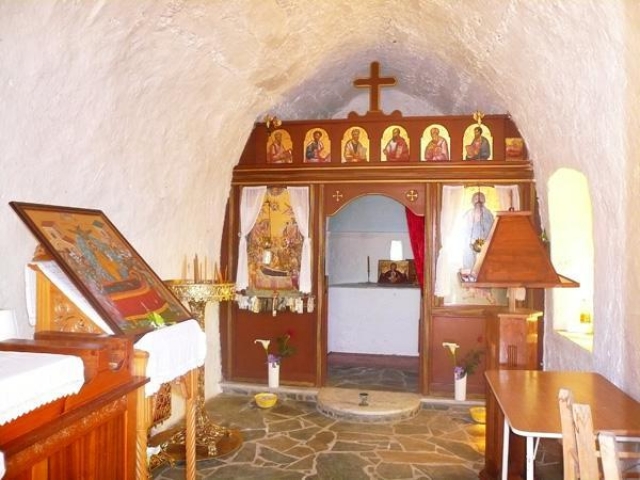
Dormition of the Theotokos church
Two kilometres of East of the village on the way to Lithines the temple of Dormition of the Theotokos (Virgin Mary) is found. History reports it to have been built by Byzantines during the years of their sovereignty (961-1204). Was a monastery dependency of the monastery of ‘Kera’ – Virgin Mary in Pilalimata and it was destroyed from Turks invaders. The temple of Virgin Mary was restored unknown from who and when but it was destroyed once again by Turks from unknown cause. It is said that Turks of Daphne who had their flocks ranging in the area, did not allow the restoration of the Temple. In 1935 again the temple was restored by Mrs Maria Santimpantaki from the village Katsidoni of Sitia and the opening ceremony was held in the same year.
Πηγή:
«Πεύκοι “Τόπος και Ιστορία”», Γεωργίου Θ. Καναβάκη (Καναβογιώργη), Έκδοση Κοινότητας Πεύκων, Ιούλιος – Αύγουστος 1994
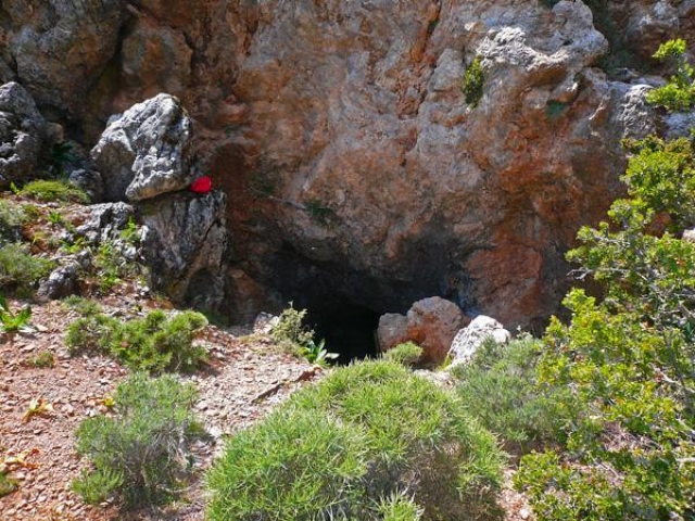

Apoloustres
The Cave of Apoloustres is located 2.5 km north of the village and it is a gulch of 15-20 metres deep as well. A big gallery 60x15 (WxH) metres and a non visible entrance, made this cave the safest covert of the villages near Pefki.
In 1930 visitors found copper coins depicting a man’s face and the name Marcus Aurelius was stamped around the face on each coin.
Access to that cave is very easy as cars can reach 150m before the entrance and the terrain is not considered difficult to cross.
Both caves, Vreiko and Apoloustres were used as coverts by the locals when they were in danger due to piracies and invasions, and many people were saved.
At this point is very important to say that both caves are not equipped with lighting and visitors must have their own equipment to explore the caves.
Πηγή:
«Πεύκοι “Τόπος και Ιστορία”», Γεωργίου Θ. Καναβάκη (Καναβογιώργη), Έκδοση Κοινότητας Πεύκων, Ιούλιος – Αύγουστος 1994
This village on the road to Stavrohori is about 25 km from Sitia (South West) .
It is divided into two groups of houses called Apano Kria and Kato Kria. In the Venetian census of 1583 it was listed as Cria with 176 inhabitants.
The local people pronounce the name «Kriya» and insist that as it gets very cold there in the winter months the name of the village reflects the climate, (krio: cold), and it seems quite likely that this is the true origin of the name. Above Kato Kria, on the hill called Trapeza, traces of ancient ruins are to be found. Near the village, on the hill of Agios Georgios, next to the chapel after which the hill has been named, are the remains of Late-Roman water cisterns. The top of this hill is surrounded by the walls of a Venetian fortress known as Monte Forte. The Venetians must have built it in the 13th or 14th century ΑD for the protection of the lahds they had seized. It is contemporary with the forts of Sitia, Liopetro, Agios Stephanos and Voila.
Ιn 1971 eχcavations were started on a group of graves at Tsachali, a deserted spot on the lower slopes of the hill; the dig was completed in 1977. It proved to be a cemetery of the Sub-Minoan and Protogeometric periods. There were many unpillaged graves but the grave-goods were generally of poor quality. Α complete stone-lined tomb with its funerary pithos and human remains was removed and is on display in the Agios Nikolaos Museum. This of course was a task requiring patience, precision and skill. Some of the walls of the mosque are still standing at Kato Kria. Not far away was the settlement of Visas, listed in 1583 as Visia with 107 inhabitants - today it is only ruins.
From the book "Sitia", N.Papadakis, Arcaeologist,1983


The folklore museum was founded after proposal of Mr Mihalis Mihailidis and Nikolaos Lantzanakis and established under the presidency of Mrs Koula Aggelaki.
For the establishment and organisation of the folklore museum, local and prefectural authorities assisted. In addition, residents of the village offered invaluableness heirlooms which were owned by their ancestors.
The museum includes objects that were important in the everyday life of past eras. For example: household equipment, weavings, loom, agricultural tools, spinning oil lamp machine, vine-press tools, clay pots jars, candlestick and many other tools.
The museum is open from April to October between 9:00 am to 2:00 pm. .
For further details Telephone:28430-51255.

Vreiko
The cave of Vreiko is located about 2km north-east of the village. It is a cave and gulch and the known depth is 25-30 metres. The Entrance is an open and flat place that looks like a threshing floor. In the entrance there are stairs that make the entry and exit to the cave easier. A fig tree has grown at that place and its bouches cover a big gallery which is about 60-70 metres long. At the entry and the end of the gallery there are signs from the Neolithic Era.
South of the entrance is the gulch (Latsida) where there is water which dries up during autumn. At this part of the cave there metallic stands to assist people on their ways up and down. In every corner of the cave there are beautiful stalactites and stalagmites.
It is not difficult to visit this cave as cars can go about 250 metres before the caves entrance on the west side and almost on a daily basis, during summer months people visit the cave.
Πηγή:
«Πεύκοι “Τόπος και Ιστορία”», Γεωργίου Θ. Καναβάκη (Καναβογιώργη), Έκδοση Κοινότητας Πεύκων, Ιούλιος – Αύγουστος 1994
This village which has plenty of water. Is located about 2 km away from Kria and 27 from Sitia on the Stavrohori road.
The name certainly comes from the plant (Dafni: laurel or bay tree). It is entered as Dafni with 187 inhabitants ?π the 1583 Venetian census. The 60 Turkish families who lived in Daphni belonged to the sect of Αli, adopted son and son-in-law of Mohamet, and were the most fanatical in the whole district, abhorred even by the more orthodox members of their own religion. Christians in the village and any Greeks passing that way underwent the most horrible sufferings. Thus when in 1897 the Christians surrounded the Turks in the mosque of the village, they showed nο clemency and, having killed 130 in the mosque, they later rounded up another 30 who had escaped and were hiding in the cave οn the mountain Kopro Kefala in the Kria district.
From the book "Sitia", N.Papadakis, Arcaeologist,1983
The name certainly comes from the plant (Dafni: laurel or bay tree). It is entered as Dafni with 187 inhabitants ?π the 1583 Venetian census. The 60 Turkish families who lived in Daphni belonged to the sect of Αli, adopted son and son-in-law of Mohamet, and were the most fanatical in the whole district, abhorred even by the more orthodox members of their own religion. Christians in the village and any Greeks passing that way underwent the most horrible sufferings. Thus when in 1897 the Christians surrounded the Turks in the mosque of the village, they showed nο clemency and, having killed 130 in the mosque, they later rounded up another 30 who had escaped and were hiding in the cave οn the mountain Kopro Kefala in the Kria district.
From the book "Sitia", N.Papadakis, Arcaeologist,1983


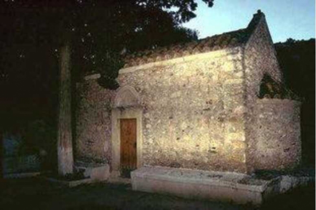


In 1957 the Municipal School above the village was built by personal work of men and women of the village. Prior to this there was a school built in 1911 in front of the church it was inadequate for school. The old school building converted to house and it is still maintained but unoccupied. In the earlier years when there was no school in the village students had to walk to the village Stravodoxari or currently known as Stavrochori, and then to the school of Agios Stefanos.
After 1897 during the years of Cretan State a school was founded in the village. Until then for the school purposes a room of local houses was utilised that students’ parents offered every year free of charge. There were not any desks or chairs and each student has to care of his seat, usually a small stool made from trunk. Books were not available to students. Only the teacher had some books and in a limited number. The students for writing were using a black stone plate, on which they were writing using stone from clay.
The school of Pefki hereafter stands proudly on the top of the slope that the village is and it functions as Folklore Museum of Former Community of Pefki which maintains the Cultural Association of the village.
Today a modern school functions in Makry Gialos, as well as High school and Lyceum.
Πηγή:
«Πεύκοι “Τόπος και Ιστορία”», Γεωργίου Θ. Καναβάκη (Καναβογιώργη), Έκδοση Κοινότητας Πεύκων, Ιούλιος – Αύγουστος 1994


 Login with
Facebook
Login with
Facebook