



 Upload your photos for Kalergi Shelter and share them with us!
 Press here.


 Address:
Λευκά Όρη
Address:
Λευκά Όρη  Telephone:




Places near Kalergi Shelter
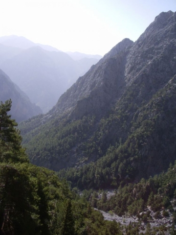

Samaria or the Samaria Gorge is one of the main sights of Crete. Every tourist who visits Crete will have heard of this beautiful gorge or soon will.
Samaria Gorge is found in the White Mountains of south-west Crete in the district of Chania. They are called the White Mountains because the sun shining on the limestone rock of their peaks make them appear that colour.The capital of the district of Chania is the town of that name. It`s a very popular tourist destination on the north coast of the island. If you look at a map of Crete you will find the Samaria gorge directly south of the town but on the opposite coast.The White Mountains contain over forty gorges of various sizes. The best known are Imbros Gorge, The Gorge of Agia Irini and the Samaria Gorge which is definitely the most famous of them all. Even though these gorges are all to be found on the same part of the island of Crete, they all have different characteristics.Samaria Gorge is named after a village of that name which is found about halfway down the gorge. The village in turn gets its name from a small 14th century church sited close by. This is the church of the Holy Mary, in the Greek language, "Osia Maria." So it is easy to see where the name Samaria comes from!The village has been deserted since 1962. The last inhabitants had to leave when the whole area was designated as a National Park. Although many of the old houses still remain, they only act as accommodation for the Park wardens. The old church of Osia Maria is still there, a little way out of the village.All the gorges in the Crete Mountains in Chania were formed by the same geological process. Water ate away the soft limestone rocks over thousands of years after the land had been uplifted by seismic activity. This water erosion has also led to huge numbers of caves being formed. There are as many as 3,000 over the island. A lot of these caves are archaeologically and religiously significant. Over a 100 of the caves have churches in them.The Samaria Gorge starts near the small town of Xyloskalo on a level area in the White Mountains called the Omalos Plateau. The name Xyloskalo can be translated as "wooden stairway." This is because the locals had built just that thing to help them enter down the steep opening into the gorge.The Omalos Plateau is over 1,200 feet above sea level and the gorge runs in a southerly direction from there down to the south coast of Crete near the village of Agia Roumeli.Of all the things to do in Crete visiting the Gorge of Samaria is a must for many tourists, especially those on Crete walking holidays. Mnay Crete excursions are based around this great hike.Coaches will collect you early in the morning and take you to your starting point at Xyloskalo in the Crete mountains. Once you have completed the hike and reached Agia Roumeli on the coast, you catch a ferry boat to the nearby port of Hora Sfakion where your coach will collect you once more.The locals call the gorge "Farangas" which means "great gorge." They also like to claim that it is the longest gorge in Europe, but that is debatable.What is certain is that in some places it can definitely be counted amongst the narrowest!The most dramitic part is a a place known as "Sideroportes" or the "Iron Gates." Here the Samaria gorge is so narrow, being about four metres wide, that you feel as though you can reach out and touch both walls at the same time.If you look up at the cliffs, which rise almost vertically above you for 350 metres, you feel totally overawed!The journey down the gorge, from Xyloskalo to Agia Roumeli on the coast, is about 18 kilometres and although the hike is not an easy one, it is extremly beautiful. The path follows a clear stream which goes through heavily scented pine forests of tall Cypress trees. There are many olive trees and some small fields with low stone walls.The Samaria Gorge is only open to visitors between the beginning of May and the middle of October. There a charge for entering the gorge, at the moment it is 5 Euros. This goes towards the maintenance of the National Park. You must keep your ticket and hand it to the warden as you leave the park, this ensures that no-one is left in the gorge overnight.During the winter months you are unable to go down the gorge.This ban can even occur in the summer season if there has been rain. This is because the pretty stream you cross many times on your hike down the gorge can turn into a raging torrent. Rain or melting snow in the Crete mountains can raise the height of the water considerably.In fact the Village of Agia Roumeli, at the bottom of the gorge, was badly flooded in the 1950`s. There are still some ruined houses which are only now being rebuilt.High winds can also cause problems. Although you may not be aware of them when you are down in the gorge they have been known to cause stones to fall from the 350 metre high cliffs. In fact there are signs warning of this danger.Any walk down the gorge usually becomes a competition to spot the rare Kri-Kri.This is a Cretan Wild Ibex with distinctive curved horns. It was introduced into Samaria gorge as a refuge for it. In fact this is only one of two places it is to be found.If you are very lucky you may spot some rare birds such as the Griffon Vulture, Bonelli`s Eagle and the Golden Eagle.One thing about Samaria Gorge you should be aware of is its popularity. During the tourist season there will be lots of people hiking through it every day.The beauty and dramatic quality of Samaria Gorge make it one of the most popular gorges to visit in the world.


Hiking and nature close to Zourva village: From Lakki Village - Vrisi gorge and Vrissi water source - Zourva village.
We started from Lakki, a village on the way to Omalos plateau, 460m asl.
The path is marvelous and we enjoyed every step. Our direction was eastward. We were walking discovering gradually all the surprises of this gorge.At the end of the gorge there is a cave with an underground river, from which the gorge took its name (Vrissi=Fount).
Facing the gorge from above we stayed surprised: rugged yet beautiful places, cypresses, oaks and their amazing flowers dominating the view. Unfortunately in the midst of this beauty the signs of the destructive presence of man with the recent fires is obvious.
We are on the way to the cave - fountain and now the path began to be uphill. This old trail becomes more and more difficult.It has been already 3 hours and we approach our destination, the fountain which supplies water the villages Zourva and Lakki, an impressive mountain location with an altidude of 790m.

On the right hand side of the road descending from the Omalos plateau to Chania, there is the large canyon-cave called Honos or the Cave of Tzanis, which served as the den of the chieftain Tzanis Markos during the first years of the Turkish invasion.
Nicknamed ‘Fovos’ (fear), he struck terror into the hearts of the invaders. The cave was explored for the first time by speleologists from Chania and France. It is 2.5 kms in length, and the height of the cavern is 241 metres; it forms a huge covered gorge.
Opposite the entrance of the cave of Tzanis, on a small knoll, there is the Tower and chapel of the famous rebel chieftain from Lakki and hero of the Lefka Ori, Hadzimihalis Yiannaris (1851-1916). One of the pioneers in the uprisings of 1855 and 1856 and a major contributor to the great uprising of 1866-1869, he was imprisoned many times by the Turks but always managed to escape. On one occasion, about to attempt the almost impossible escape from the fortress of Firkas in Chania in 1860, he vowed that if successful he would build the small chapel of Agios Panteleimon in Omalos next to the Tower. He kept the vow and, honoured as a general, was buried there according to his own wishes, in his old "lair". Great both in stature and soul, he served as a general leader of the district of Kydonia in Chania from 1866 to 1898.
In the picturesque village of Zourva by an region with genuine Cretan hospitality and beautiful walks, the visitor can experience intense emotions. Opposite the village hidden within the cliffs and pines is located the water source and the gorge of Tromarissa that starts from there.
The track we follow starts at an altitude of 600m in the village of Zourva, and leads, by a regular but easy ascent through a pine trees forest, to a waterfall situated at 1000m high in the mountain landscape. Soon you are dominated by the view of the Madares, the White Mountains. The name of the gorge and region is linked to popular myths about fairies and elves , as well as significant moments of our modern Cretan history .
Access to the canyon by about two hours walking througt a well signed path Zourva Village - Tromarissa, which belongs to the network of Green trails, which recently (2008) completed the Mountaineering Club of Chania.
This is a technical canyon and the descent requires knowledge with rope. It has 20 technical descents with the highest at 30 meters height, and other smaller which does not require ropes, but rock rappelling. The Tromarissa essentially is a stream and has water only after a downpour in the sorrounding mountains and that makes a visit possible almost all the time for lovers of canyoning (technical canyoning). In the riverbed, one encounters rich flora of herbs, such as the notorious diktamos, cypresses, wild fig trees etc. Rich is also the fauna, where in the walls of the gorge many species of birds can find shelter. Goats in the region tend to be a part of the ecosystem.
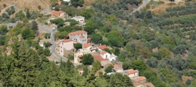

The village Zourva consists one of the most beautiful pristine mountainous destination of Hania. Administratively it belongs to one of the historic municipalities of Crete, the municipality of Mousouron. The distance of 25 kilometres from the city of Hania, south torwards the inland of the island and at an altitude of 570 metres.
In the depth of the Keriti basin, at the edges of the Lefka Ori mountains and at the foot of Mount Kaloros. The villagers maintain the pristine features of the region. The guest house is located within the built-up area. In winter the entire place is dressed in white, giving you the opportunity to enjoy yourself and even play with snow.
The residential part of Zourva is referred to for the first time in Egyptian census of 1834 consisting of 15 Christian families. The participation of the villagers was significant in the liberation battles of Crete. In 1866-69 Zourva and Meskla were the headquarters of rebellion meetings under the commands of Zimvrakaki, while at the same time the participation of the villagers in battles continued until and during the German occupation.
You can find tavernas in Zourva which offer you Cretan specialties. Relish the cretan cuisine, dishes cooked in local extra virgin olive oil.
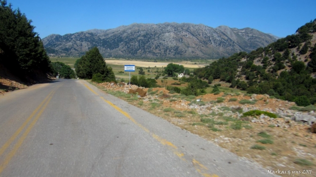

Lakkoi (Greek: Λάκκοι), commonly spelled Lakki on road signs and maps, is a village on the Greek island of Crete in the foothills of the Lefka Ori (White Mountains). The village is situated on the road between Chania and the plateau of Omalos which leads to the Samaria Gorge.
Lakkoi is 450 meters high, below the White Mountains which rise another 1,000 meters to the south. Most of the houses cling to steep slopes covered in olive and chestnut trees, reached through narrow roads or tracks that run down from the main square.The climate is cool in winter, with occasional snow, wet in spring, hot and dry in the summer. In the unusually dry summer of 2007, major brush fires broke out twice, burning about 2,000 acres and threatening the village itself.Traditionally the villagers have cultivated olives and raised goats, sheep and chickens. With limited work opportunities, the population has declined from a peak of around 2,000 to about 400 today. There are signs of growth as houses are being purchased and renovated by citizens of other European Union countries seeking low-cost retirement or vacation homes.The first historical mention of the village dates from 1263, when the Lakkoi chieftain Pentachtenis took part in a revolt against the Venetians. In a later revolt in 1570 the chieftain George Mousouris became Secretary General of the rebel forces, based in the nearby village of Meskla.After the Ottoman conquest of the island, the people of Lakkoi were involved in periodic revolts, notably the revolt of 1821-1828 during the Greek War of Independence, where an Ottoman army of 5,000 men led by Latif Pasha of Chania was routed in a pitched battle at Lakki. In the great rebellion of 1866-1869 Katerina Stamataki of Lakkoi was a distinguished woman revolutionary.During the Battle of Crete in May 1941 and the days that followed, four hundred and eighty five men and women resisted the German occupiers, and sixty eight Lakkoiotes lost their lives in the fight for the freedom of Greece.


A small mountainous ancient city, built inside Samaria gorge near the banks of the river. The city developed in the ancient years and according to tradition it was the birthplace of Artemis the Britomartis, called Diktini, who was the daughter of Zeus.
In 1991, they found an outdoor sanctuary near the church of Agios Nikolaos as well as many bronze and iron, arrows and spears. That was probably the oracle of Apollo or else, the Kirikion Andron. It is said that the nymph Akakali, wife of Hermes and daughter of Minos was worshipped there.


 Login with
Facebook
Login with
Facebook