



Your Position:
Unknown
Λεπτομέρειες ΕικόναςImage details
More Photos
 Upload your photos for Agios Georgios Aoritis and share them with us!
 Press here.


Agios Georgios Aoritis
Prefecture: Rethymno
 Address:
Ζωνιανά
Address:
Ζωνιανά  Telephone:
, Suggest


Your Opinion

If you want to tell us your opinion about this place, please leave a comment
Post a Comment:

Agios Georgios Aoritis
Places near Agios Georgios Aoritis

Zoniana village is a mountainous village of Milopotamos province belonging to Rethimnon Prefecture in Crete. It is built on the northern foot of Psiloritis mountain (Mount Ida) in an altitude of about 640 metres. It has a population of about 1,500 inhabitants, the majority of whom are occupied with agriculture and cattle-breeding. The legends and traditions which accompany it are lost in the depths of time. Through these pages one can find out how the village was named, how one can visit it, learn about its history, look at several of its pictures and some other interesting sights, and finally read some myths and legends related to it.The history of the village is lost in the depths of time since according to the legend its formation and name are closely related to Zeus. It also coincides with the history of Axos since the province of the village was part of its realm as well as the area of Anogeia.In 1577 Barozzi cites it as a separate settlement with the name So. Since then the separate history of the village begins for which, however, we do not have any written documents until 1821. Nevertheless, both the recent past and the present of Zoniana manifest its farther past. One thing is beyond the shadow of doubt: that it was never inhabited by Saracen, Venetian or Turkish conquerors, that its population has always been purely Greek and that it always took part whenever Greece called for help. In more detail, the inhabitants of Zoniana participated in the Revolution of 1770 in every way they could and also took care of persecuted Sfakians.In 1821 M. Melitakas from “Zou Lakko (Zoniana) Mylopotamou (it is written in one paint of him at Historical Museum of Heraklio, Crete )”, chieftain of Milopotamos province, fought against the Turks throughout Crete. He got injured in a battle in Brachimio and died because of that wound later. His name is reported at the Book of V. Psilakis “Istoria tis Kritis” page 320. In 1866 twenty inhabitants of Zoniana with Parassirogiorgis decided to leave the safety that the mountains offered them and go to Arcadi, where seventeen of them were killed.Six months later, on May 8 1867, the inhabitants of Zoniana along with those from Milopotamos stroke Omer Pasha Latas in Pera Chalepa. The Turks beat a hasty retreat and the inhabitants of Zoniana took a portable canon as loot, carried it to Zoniana and hid it. Today this canon is in the Maritime Museum of Crete in Chania. On the next day, May 9, the numerous Turkish army wore down the resistance of the inhabitants of Zoniana and entered the village. They interrogated the old and the sick who could not leave the place in order to find the canon. Since no one confessed, they slaughtered everyone and set the village in fire. Along with it the forest of the gorge was also burnt.In November of the same year Kumandar Redic Pasha tried to build a Tower in Kafkaloudi (Amigdalokefalo) like in all the other villages. He did not succeed to do so because the inhabitants of Zoniana did not leave him at ease. Day and night they attacked him and then left (klephtopolemos) and they decimated his soldiers and builders. In turn, he burnt everything that the inhabitants of Zoniana had managed to rebuild and departed. This clearly demonstrates that the village of Zoniana was set on fire twice within six months (both in May and November). According to a song of that period the village had been burnt yet another time: “That’s the third time that the village is burnt but even if it is burnt three hundred times we will not obey the Aghas.”The years went by but the inhabitants of Zoniana did not cease to fight the Turks. They went to Gazi and Servili and along with the inhabitants of Milopotamos and Malevizio they trapped the Turks in Heraclion. There is still today in Gazi a location called “Michanes” which took its name from the conduits that the inhabitants of Zoniana dug and then blew up as the Turks were getting closer. During a battle in which the rebels beat a hasty retreat, they left the flag behind. The inhabitant of Zoniana Michalis Kavvalos or Kaprakis got back and in a cloud of bullets he took it and left. For that reason he was awarded a prize by the Cretan community as the saver of the flag. That is the place where Michalis Nikiforos was killed.During the Balkan Wars thirteen inhabitants of Zoniana sacrificed their lives. During World War II (Northern Epirus – the Battle of Crete – the Greek Occupation) nineteen inhabitants of Zoniana were sacrificed in the name of Greece.Last but not least, during the Greek Civil War another four people lost their lives. Maybe those were the only lives lost in vain however they obeyed to the calls of the Greek government.Text: www.zoniana.gr


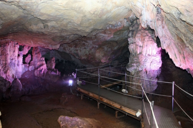
The most important among the potholes-caves of the Anogia - Petradolakia area (close to Nida Plateau), and one of the most important of Greece, is Tafkoura. It is the second deepest cave in Greece and one of the deepest in the Balkans, reaching -860 meters below the surface.
It was formed within the platy marble of the Psiloritis area, probably having started on one of the many faults that fragment the rocks of the area. However, water followed the upward movements of Psiloritis, digging the rocks deeper and deeper to reach sea-level, finally forming this long pothole-cave system. The total, mapped length of the cave is about 6,5 kilometers and it is the longest of Crete. Tafkoura, together with the nearby caves Tafkos (-475 m.), Diplotafki (-400 m) and Mythia Kampathoura (-270 m.) caves form the deepest karstic .water conduits of Psiloritis, though which rain and the snow water goes to the Almyros spring near Heraklion.
Life adapted in these underground worlds giving rise to species that can survive in the ageless darkness as easily as their ancestors did on the surface. Apart from the different species of bats; snails, spiders, false-scorpions, woolise and insects are the main groups which constitute the fauna of Psiloritis’ caves.
The caves however are closely related with the people of the mountains and their diachronic activities. From their first appearance on the island the caves were their places of worship, the houses, the cheese-dairies, refuges during difficult periods and also sacred places. That’s why most caves have a significant archaeological and historic value (and like all the caves in Greece are regarded as potential archaeological sites).

The canyon of Zoniana is located south of Zoniana village at the north side of Idi or Psiloritis mountains, Rethimno prefecture. Starting at an altitude of 950m, it ends at the south side of the village at an altitude of 650m.
Through the gorge runs the "serpentine" Oaxis river that has water till spring. The gorge is easily accessible and safe for hiking, as its slope is small. Zoniana village is a mountainous village of Milopotamos province belonging to Rethimnon Prefecture in Crete. It is built on an altitude of about 640 metres. It has a population of about 1,500 inhabitants, the majority of whom are occupied with agriculture and cattle-breeding. It is situated 43km away from the capital city of Heraklion, but it is also a nice excursion from Rethymnon.
Through the gorge runs the "serpentine" Oaxis river that has water till spring. The gorge is easily accessible and safe for hiking, as its slope is small. Zoniana village is a mountainous village of Milopotamos province belonging to Rethimnon Prefecture in Crete. It is built on an altitude of about 640 metres. It has a population of about 1,500 inhabitants, the majority of whom are occupied with agriculture and cattle-breeding. It is situated 43km away from the capital city of Heraklion, but it is also a nice excursion from Rethymnon.


migeros plateau develops just below Psiloritis summit at an altitude of about 1700m. It is formed by a series of small and large depressions which are created along a big fault that fragments all the nortern area of Psiloritis Mountains.
A trail starts from Migero's plataeu leading up to the summit of Psiloritis oferring also a spectacular view of the dolines and the horizontal layers of rocks.
Settlement of Livadia district that lies at an altitude of 610m and it is known since 1577.
The name of the village comes from the Dorian krini, testifiying that the village has a very long history indeed. The residents of the settlement participated in the revolutionary war of 1868.


 Login with
Facebook
Login with
Facebook