
Your Position:
Unknown
Λεπτομέρειες ΕικόναςImage details
More Photos


Press here.


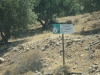
Agios Georgios Samakidis
Prefecture: Lassithi
, Suggest
, Suggest
Your Opinion

If you want to tell us your opinion about this place, please leave a comment
Post a Comment:

Agios Georgios Samakidis
Church of St George of Samakidis
South-east of the village in a distance of 3,5 kilometres and another so long from the settlement of Analypsis is found the little church of St George which in the past was known as Monastery of Samakidis.
It is built under a cavernal precipice at the point where history reports that there was a hermitage of nuns. Writings regarding the Temple or the monastery have not been found. Probably any writings were disappeared at the long-lasting possession of Turks. Tradition and history report that in 1471 A.D. by the raid of Turks most villages of Sitia province and Abbeys were destroyed. «…»
Πηγή:
«Πεύκοι “Τόπος και Ιστορία”», Γεωργίου Θ. Καναβάκη (Καναβογιώργη), Έκδοση Κοινότητας Πεύκων, Ιούλιος – Αύγουστος 1994
Places near Agios Georgios Samakidis
Pilalimata is an old small village south of Pefkoi, a continuance of Analypsi, which is on the way to Sitia and about 1000m far from the seacoast, the beaches of Diaskari and Lagkadas.According to tradition its legacy started prior to the sovereignty of the Turks; yet it is not known for a fact who founded the village. In line again with tradition it is widely believed that the Byzantines have seized large territories of land that was occupied by Saracens and built northeast of Pilalimata the great monastery of Kera Panagia (Virgin Mary). Following native population built a metochi (Monastery Dependency) 350m away from the Abbey, where they produced livestock and cultivated land for living. During the Venetian rule it is said that a large number of the region’s properties and part of the monastery was granted to Venetian settlers; others say that Pillalimata was built by the Venetians, but after the destruction of the monastery by the Turks in 1941.
The landscape of the village is flat, and the land known for its fruitfulness; that is mainly the reason that this particular estate was always a property of high ranking officials of the conquerors, Byzantines, Venetians and Turks. The greater region of the village is also referred to the Byzantine Loukas Litinas or Lithinas, whose descendants are believed to be the residents of the nearby village "Lithines". Pilalimata was his tsifliki (private estate), and he was left in history as one of the most dreadful tyrants that the region has seen.
It is alleged that the name Pillalimata comes from the word ‘lima’ which means profit or taken from somewhere. It is also said that the village’s name comes from the word ‘limata or pola pila’ (muddy); a product of geological phenomena caused by a nearby river. Others say that the village was named after a Turkish ‘Aga’ (Ruler), whose name was Pilalis. During the Greek Independence war on 1897 the village was destroyed by fire, and four Turks were killed. Residents of Pefkoi collected the debris of three cypresses, and built onto it the temple of the Orthodox church of the Three Hierarchs.
Πηγή:
«Πεύκοι “Τόπος και Ιστορία”», Γεωργίου Θ. Καναβάκη (Καναβογιώργη), Έκδοση Κοινότητας Πεύκων, Ιούλιος – Αύγουστος 1994

On the road that passes from the settlement of Analypsis is built the little church dedicated to the Ascension of Jesus. Its construction began in 1908 from residents of Pefki at a location that had the name “Big piece or Chani”. Its completion was delayed up to 1930, due to the long-lasting wars from 1913 until 1922 and other unfavourable situations. Then a villager, who was retired officer of police force and tradesman in the town of Ierapetra, Charilaos M Manoysakis sponsored its completion which took place in 1933 from the craftsman Stefanos E Karamanolakis from the Krya village. The opening ceremony of the Temple became the 1934. In 1983 suffered damage due to arson, the repair then was sponsored by the ship-owner Antonios Lelakis from the town of Sitia.
Πηγή:
«Πεύκοι “Τόπος και Ιστορία”», Γεωργίου Θ. Καναβάκη (Καναβογιώργη), Έκδοση Κοινότητας Πεύκων, Ιούλιος – Αύγουστος 1994
Prospilia is a relatively new settlement in the area. It is built 500 m north of the seacoast on the road from Analypsis to Pefkoi. The development started in 1970 and is still growing.
The name Prospilia is given to that area as there are many tiny caves of white stones. Prospilia, ASprospilia, Aspra Spilea (White Caves) is the conversion of the words describing the characteristics of the area.
Πηγή:
«Πεύκοι “Τόπος και Ιστορία”», Γεωργίου Θ. Καναβάκη (Καναβογιώργη), Έκδοση Κοινότητας Πεύκων, Ιούλιος – Αύγουστος 1994


Church of St Konstantinos, St Helen and the Three Hierarchs
The church of Three Hierarchs is the parish church of the village. The church has two aisles with the south one being dedicated to St Konstantinos & St Helen and the north aisle is dedicated to the Three Hierarchs.
From local history and the dates written on the pictures it is known that the first aisle was built between 1840-1850. The second aisle was built between 1897- 1902 from the locals as an offering after their victory against Turks during the night of 29th - 30th of January which is the Saints’ day. It is said that the temple of the Three Hierarchs is made of the remaining of three cypresses that were set on fire by the Christians against the Turks during the battle in Pilalimata in 1897.
Πηγή:
«Πεύκοι “Τόπος και Ιστορία”», Γεωργίου Θ. Καναβάκη (Καναβογιώργη), Έκδοση Κοινότητας Πεύκων, Ιούλιος – Αύγουστος 1994

Holly Mother the Evangelist
It is an early era Christian Temple, 100 roughly metres south-east of the village, it was destroyed by the Saracens initially in 823 A.D. and then twice from the raid of Turks in 1471 and the years when they occupied the island of Crete. It is also said that the temple was destroyed by an earthquake in 1612. The first restoration is said to have taken place by the Byzantine settlers of the village. For the destructions by the Turks it is not known when and who did the restoration, but probably it was restored by residents who survived.
The restoration after the earthquake is said that it became from a woman who is reported with the name “Maria”. She was killed by the Turks when they made their last destruction. She is buried in the Temple in a grave under arc-shaped vault that she had made by herself. For this woman it is said that she was very rich and benevolent. Her house was built 500 metres south-east of the temple at the end of a bluff and remaining of her house can still be seen in that location.
Πηγή:
«Πεύκοι “Τόπος και Ιστορία”», Γεωργίου Θ. Καναβάκη (Καναβογιώργη), Έκδοση Κοινότητας Πεύκων, Ιούλιος – Αύγουστος 1994

Holy Cross and St Panteleimon
North of the village on the top of the mountain is built the small country church of Holy Cross and a little outer and eastern of the village by the street the little church of Saint Panteleimon. Both were built in the decade 1880-90 by Mr Stavros Kassotakis who is reported as ‘Kasotostavris’.
The place of Temple of Holy Cross offers a scenery view that impress the visitor as the village of Pefki, the slopes form a magnificent landscape ending at the Makry Gialos area and Libikon Sea.
Πηγή:
«Πεύκοι “Τόπος και Ιστορία”», Γεωργίου Θ. Καναβάκη (Καναβογιώργη), Έκδοση Κοινότητας Πεύκων, Ιούλιος – Αύγουστος 1994


During summer, on a daily basis, buses occupied by Greek and overseas tourists arrive at Pefkoi village, where they walk through the alleys by taking photos of village and the surrounding area. Every visitor expresses their admiration to the locals for the beauty of the village, and then leave the place by walking through the path west of the village to Analypsis (village which nowadays is joined with the Municipality of Makry Gialos after the rapid growth of the second. ).
Walkers on their way to Analypsis, enjoy the natural beauties of the place, the sun, fresh and full of aroma air of countryside, the mountains and the sea. Beginning from the village, they pass through the olive groves and they pass from the abandoned ‘Ilias’ watermill’ as it is known today. Historic reports referring watermill as abandoned since the years of Saracen Arabs up to the years of sovereignty of Turks, where a chased man from Messara, whose surname was Lantzanis, rebuilt the watermill. The mill in its history was operated by various owners until 1915, with the last owner to be Ilias N. Kanabakis. Apart from grinding cereals Ilias used the mill to process olives in an olive press that he had made for olive oil production. Around 1925 watermill once again was abandoned as the waterflow for the operation of the mill was not enough.
After the watermill, follows the attractive and scenery Gorge of Pefkoi. Its length is about 1000 m, width is an average of 90 m and depth from 10 to 120 m. It is full of pines, platens, locusts, hollies and other forestall plants
At the exit to the south, walkers can taste drinkable spring water. Its fauna during the past was very rich but today only a few is remaining due to continuous deterioration from locals and foreigners. The photographing can become from everywhere with different background each time. Nowadays a pathway has been opened that leads from the gorge entrance to the exit.
Next to the exit of Gorge follows the area known as Megali Lagada (big valley) of ‘Pisokamino’. The slopes are covered mainly by pines and various trees. Continuing on the pathway is an area called ‘Volakas tou Sarakinou’ about 500 metres north of the settlement ‘Aspros Potamos’ (White River). History of ‘Volakas tou Sarakinou’ says that when Saracens invaded in Crete, the locals found a Saracen hiding under a big rock and killed him. From that time this rock was named ‘Volakas tou Sarakinou’. This rock’s top surface is a bit level with a small inclination where there are many stones of a size of an egg. These have become object of observation and query of foreigner passerby, how the stones are placed there and how they remain on the rock. Locals relate this to the difficulties of poor people due to the wars, the raids and other conditions of earlier years. Starvation was their main problem and when hungry children were passing by the rock, were throwing stones to the top of the rock. If the stones remained on top and not rolled down, kids were leaving from the place, with the impression that when they arrive at their homes they will find to eat plenty of food. The opposite would happen if the stone rolled down. Therefore it is believed that the remaining stones on the rock were thrown by the kids.
After that big rock, the pathway connects to the main road, and after the valley of Pisokamino, reaches the attractive settlement of Aspros Potamos (White River).
The same road leads to Analypsis and Makry Gialos, the best tourist place of southern Prefecture of Lasithi.
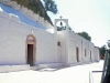
Midways of turnpike road to Analypsis, the tourists can visit the small church of formerly Abbey of Saint George of Samakidi that built by the todays honoured Saint, ‘Iosif (Josef) Samakidis’ or ‘Samakos’.
The church is located on a big slope that is covered by pines with other trees. The south of that slope meets with the “Katsoulis’ Gorge” which also has its own beauty.
During that route walkers have the chance to see the beautiful landscape view to meet the endless blue sea of Libykon.
Πηγή:
«Πεύκοι “Τόπος και Ιστορία”», Γεωργίου Θ. Καναβάκη (Καναβογιώργη), Έκδοση Κοινότητας Πεύκων, Ιούλιος – Αύγουστος 1994
Aspros Potamos (White River) is referred to be the oldest settlement of the area of Pefkoi. It is located about 1 km north of the beach of Makry Gialos.
Narrations report that the settlement was wealthy in the past, but because of the close distance from the sea, it was subject to incursions and as a result its residents had to abandon the place and move to the northern areas that were safer for them. It is also reported that the first residents of Pefkoi were the residents of Aspros Potamos. The area can be described as spectacular. The mountains from the North and the valley from the South that reaches the settlement of Analypsis, the stream of Aspros Potamos which crosses the settlement, form a unique landscape.
Most of the old houses of the settlement, which were built from stone and soil, have been refurbished and attract many visitors.
Πηγή:
«Πεύκοι “Τόπος και Ιστορία”», Γεωργίου Θ. Καναβάκη (Καναβογιώργη), Έκδοση Κοινότητας Πεύκων, Ιούλιος – Αύγουστος 1994
Church of St James (St Dimitrios)
In Pilalimata, in the decade of 1980 Mr Georgios Dermitzakis from the village of Lapithos and his spouse Ekaterini Ioannou Chatzakis from Agios Stefanos offered a big part of their land and a respectable amount of money for building the temple of Saint Dimitrios. After their death construction of the temple was carried out by the residents of Pilalimata and others from the nearby areas, with the priest Emmanuel Chatzakis being the organizer of their endeavour. Finally the opening ceremony was held on the 26th-10-1993.
Πηγή:
«Πεύκοι “Τόπος και Ιστορία”», Γεωργίου Θ. Καναβάκη (Καναβογιώργη), Έκδοση Κοινότητας Πεύκων, Ιούλιος – Αύγουστος 1994

Olympia apartments Makrigialos >> sea view apartments in southeast Crete >> Beachfront accommodation in Makrys Gialos CreteOlympia apts is a beautiful, recently rebuilt in the heart of Makri Gialos Bay, lying right in front of a sandy, Blue Flag awarded beach, with the ambition of winning your hearts because we have put our love and effort in order to satisfy your elegant pure choice.

Dormition of the Theotokos church
Two kilometres of East of the village on the way to Lithines the temple of Dormition of the Theotokos (Virgin Mary) is found. History reports it to have been built by Byzantines during the years of their sovereignty (961-1204). Was a monastery dependency of the monastery of ‘Kera’ – Virgin Mary in Pilalimata and it was destroyed from Turks invaders. The temple of Virgin Mary was restored unknown from who and when but it was destroyed once again by Turks from unknown cause. It is said that Turks of Daphne who had their flocks ranging in the area, did not allow the restoration of the Temple. In 1935 again the temple was restored by Mrs Maria Santimpantaki from the village Katsidoni of Sitia and the opening ceremony was held in the same year.
Πηγή:
«Πεύκοι “Τόπος και Ιστορία”», Γεωργίου Θ. Καναβάκη (Καναβογιώργη), Έκδοση Κοινότητας Πεύκων, Ιούλιος – Αύγουστος 1994

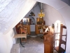
The folklore museum was founded after proposal of Mr Mihalis Mihailidis and Nikolaos Lantzanakis and established under the presidency of Mrs Koula Aggelaki.
For the establishment and organisation of the folklore museum, local and prefectural authorities assisted. In addition, residents of the village offered invaluableness heirlooms which were owned by their ancestors.
The museum includes objects that were important in the everyday life of past eras. For example: household equipment, weavings, loom, agricultural tools, spinning oil lamp machine, vine-press tools, clay pots jars, candlestick and many other tools.
The museum is open from April to October between 9:00 am to 2:00 pm. .
For further details Telephone:28430-51255.

The village of Pefkoi is built in altitude of about 420 metres on the south slope of mountains that have the name of their tallest mountain top, called “Romanati”. The land is rocky at its biggest part and forms a scenery landscape of unique attractiveness.
Above the village is the mountain of Afendis-Stavros ("Stauromenos") in the top of which the homonym tabernacle has been built. South of the village, a mountainous landscape mainly consisting of soil allows the growth of olive trees, fruit-bearing trees and gardening. Big part of the landscape is covered by forests of pines, wild locust trees, olives, bushes and many other forestall plants. Travelling southern the land is more level allowing the growth of vines and greenhouse products.
The region of Pefkoi has coverage of forty thousand acres, is located 35 kilometres south-west of the Sitia town, and 30 kilometres east of Ierapetra. It borders with the village of Krya from the north, while from the south it has the Livykon sea with the scenery beaches of Analypsis, Maky Gialos, Diaskari and Lagkadas in a distance of 7 kilometres. On the west Pefkoi borders with Agios Stefanos village and with Lithines village from the east as well as the Municipality of Maky Gialos.
Πηγή:
«Πεύκοι “Τόπος και Ιστορία”», Γεωργίου Θ. Καναβάκη (Καναβογιώργη), Έκδοση Κοινότητας Πεύκων, Ιούλιος – Αύγουστος 1994


In 1957 the Municipal School above the village was built by personal work of men and women of the village. Prior to this there was a school built in 1911 in front of the church it was inadequate for school. The old school building converted to house and it is still maintained but unoccupied. In the earlier years when there was no school in the village students had to walk to the village Stravodoxari or currently known as Stavrochori, and then to the school of Agios Stefanos.
After 1897 during the years of Cretan State a school was founded in the village. Until then for the school purposes a room of local houses was utilised that students’ parents offered every year free of charge. There were not any desks or chairs and each student has to care of his seat, usually a small stool made from trunk. Books were not available to students. Only the teacher had some books and in a limited number. The students for writing were using a black stone plate, on which they were writing using stone from clay.
The school of Pefki hereafter stands proudly on the top of the slope that the village is and it functions as Folklore Museum of Former Community of Pefki which maintains the Cultural Association of the village.
Today a modern school functions in Makry Gialos, as well as High school and Lyceum.
Πηγή:
«Πεύκοι “Τόπος και Ιστορία”», Γεωργίου Θ. Καναβάκη (Καναβογιώργη), Έκδοση Κοινότητας Πεύκων, Ιούλιος – Αύγουστος 1994
Rousso Haraki
The cave called Rousso Haraki (means red stone) is at the bottom of a scenery bluff and is used as a stockyard. The cave is located 2.5km east of the village.
It is said that in 1943 40 Italian army men were hidden in the cave as they were chased by the Nazi forces for not joining them after the descend of Italy. But they were arrested by the Germans. Four of them escaped on the way to the village and five who were officers were killed later near Sitia.
Πηγή:
«Πεύκοι “Τόπος και Ιστορία”», Γεωργίου Θ. Καναβάκη (Καναβογιώργη), Έκδοση Κοινότητας Πεύκων, Ιούλιος – Αύγουστος 1994