



 Upload your photos for Agia Marina and share them with us!
 Press here.


 Address:
 Telephone:




Places near Agia Marina


At a mountainous, precipitous site, in the west mountain slopes of Dikti, at an altitude of 550 m, at 2 km from the village Malles, is built the village Christos.
According to the tradition, its first settlers would see every night at the spot where the village now stands a light, they went there, discovered an icon of the Christ hidden in the bushes, they settled there and named the village Christos (Christ).
To its every visitor, the village causes feelings of admiration about how man, armed with his faith in God, can live, prosper, take roots in a place which is almost hanging in mid-air.
It is a beautiful, verdurous village, with many running waters, traditional, unchanged by time, with narrow sloping cobbled alleys, most of the residents of which have “emigrated” to Xerokampos of Ierapetra, working in early vegetables.
Today’s settlement of Christos is old, possibly from the 11th century. The church of the Transfiguration of the Savior, in the south of the village, dating from the 18th century, was founded on an older little Byzantine church. There is also evidence of the ancient inhabitation of ancient Malla above the little church of Saint Paraskevi. There are inscriptions from ancient Malla, buildings, mosaics, ancient tombs, grave goods and offerings, coins that represent Zeus, the Labyrinth, the eagle and the word MAL.
A peak sanctuary, the temple of a goddess or god, an acropolis or a fortress of ancient Malla, the site above Saint Paraskevi of Christos is one of the most beautiful places in Crete. The picturesque little church, the sources with clear, icy waters, the square with the tavern, the gigantic planes compose a paradise on earth.
The tour in the landscapes of Christos is breath-taking. The cliffs, the gorges, the narrow pass through the rocks, the huge rocks, the karst landscapes reflect the violent changes of the geological formation of the Cretan landscape.
The plateau of Selekanos also belongs to the Local Department of Christos.
It is a valley of fairy tale beauty, with the largest uninterrupted pine forest of Crete, the church of Saint Eustace and the Panagia (Our Lady) Selakaniotissa, Stella’s coffee house and the private events hall of the cultural association of Selakanos and the luxurious stone-built mansions of the residents of Christos who invest and spend there their whole summer. The gorge of Selakanos is also famous, and so are the routes to the peaks Afentis and Lazaros of Dikti. The Selakanos green beans are also renowned, served with wild goat.
The settlement of Christos, the surrounding area and the plateau of Selakanos present an exceptional touring interest for anyone who wishes to escape from the urban routine. The natural beauties, the optical contrasts of the Cretan mountainous landscape are deified in Christos of Ierapetra.


Lapathos Plateau is 9 kilometers far to east from Symi or Simi village in Lassithi prefecure at the southern slopes of Dikti mountains. It is a hidden and unknown area on the Lasithi mountains and you have access to the plateau from Simi Village through a new asphalt road for the first 6km and a dirt road for the next 5km (see the map below).
From Lapathos starts one of the most rugged gorges in the Lassithi mountains the Holy Apostels Gorge.
The plateau of Lapathos is one of the most beautiful areas in Crete, on the southern border of the county of Heraklion and Lasithi with Kato Simi village to belong in Heraklion and Pano Symi to Lasithi, and is located in the lap of the most dense and substantial pine forest of Crete together with the adjacent Selakano and Malles forests. The whole region is full of water springs gushing from the slopes of Dikti mount. On the plateau you meet the churches of Panagia Galatoktismenis and Nistikoktismenis and St. George. The first so named because the chapel was built of mud and milk instead of water by fasting builders throughout construction. The church of St. George is situated about one kilometer outside the uninhabited settlement Apano Symi, at an altitude of 940 meters and has frescoes by Emmanuel Fokas from the mid 15th cent. On the plateau is also a beautiful church of the Holy Apostles. The visitor can see numerous caves in the area, used by rebels in the past : the Zympraga Spiliaria , the Kissospilio, the cave Leri , the Spilio of Boubouli , the Spilio Riza and Spilio Chalavra.
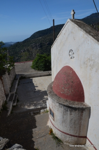
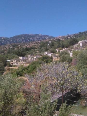
It is a small village with few residents, at 4 km in the west of the village Christos at an altitude of 600 m. The residents of Metaxohori have immigrated to the plains of Ierapetra, in Stomio, Ammoudares and Xerokampos and work in the glasshouses. The village has been renamed in 1955 from Parsas to Metaxohori to honor the Ecumenical Patriarch Meletios Metaxakis who was born here.
The Metaxohori settlement dates from the 17th century, as follows from the dating of the old churches. In the older times, Parsas, as its name was, was built at 2 km below its present position, at the site Myrtaras. Until 1929, it belonged to the Municipality of Mournies in the Province of Viannos. Since then it has been an autonomous Community, in the 90s it belonged to the Municipality of Nea Malla and today it is a Local Department of the Municipality of Ierapetra.
In 1630 it had 138 residents, in 1940 it had 281, and in 2001 55 residents were registered in the census. The permanent residents however are no more than 7.
Metaxohori has good infrastructures, an asphalt road, a renovated school, a memorial for the fallen fighters, beautiful old and new churches and the bust of the Patriarch Meletios Metaxakis. It is connected by a dirt road to the Symi villages Riza – Mournies.
The modern history of Metaxohori is rich in important persons and facts from the period of the Turkish rule and the German Occupation. The most prominent figures were Captain Diakomanolis, during the Turkish rule, and Giorgos Metaxakis, a lawyer who worked in the Prefecture and spoke 7 languages. In 1943, 7 residents of Parsos were arrested and executed at Sfakoura of Riza.
Metaxohori or Parsas, with the ruined Cretan style houses, the half-wrecked cemetery church, the wonderful natural landscapes, the view to the mountain tops, has an unbelievable tranquility, which is only disturbed by the voices of animals and birds, and a nice healthy climate. There are also amazing mountaineering routes for the nature lovers and the cave at “Kleisidi” where there are old findings, utensils and skeletons of people who took refuge there during the Turkish rule. In the north of Metaxohori, at a great altitude, there is the cave of “Neraidogoula”, which presents an inexplicable phenomenon. Sometimes in August unbelievable quantities of water flow out of the depths of the cave, flood the “Psoriaris” river and cause catastrophes. Perhaps this is why it took the name “Neraidogoula”, that is the source of the Fairy.
However, in Metaxohori, the village is dominated by the figure of the Ecumenical Patriarch Meletios Metaxakis, 1871-1935. His contribution in the posts he served into was huge and his bust adorns the central square of Ierapetra.
Metaxohori today waits to be repopulated, to be revived, since it has a wonderful climate and its air is scented by the verdurous mountain slopes of Dikti. Its few residents experience the tranquility and the solitude waiting for the emigrants, the mountaineers, the nature lovers to come and admire the village of the Patriarch Meletios Metaxakis.


A small village built at an altitude of 540 m in the south parts of the mountain Dikti at the borders of the province of Ierapetra-Viannos. The imposing mountains above the village, the south horizon among the olive-covered hills and in the lower villages, the cool climate create in you a sensation of bodily and spiritual well-being at this balcony of the Cretan nature.
Five settlements, two of them uninhabited today, constituted the Community of Riza, now a Local Department of the Municipality of Ierapetra.
Sfakoura is in the east, with the church of the Holy Cross, the cemetery, the memorial of those fallen during the German Occupation, and the ruins of Riza’s “Koules”. Here the Greek flag was raised by the guerillas of Captain Bantouvas.
Here the atrocity of the conquerors was manifested, as testified by the sculls of the neomartyrs with the coups de grace, as in Kalavryta.
Another settlement is Zourva or Riza, as it was renamed, and in the west, the settlement of “Kaimenos”.
Abandoned settlements are Tsikaloudiana, in the entrance of the village, taking its name by the Tsikaloudakis family who lived there, and the Panakiana, a little below the village, taking their name from the Panakakis or Panakomihelakis family.
Riza is an old medieval village, a natural stronghold, with history, civilization, legends and traditions. The settlement “Kaimenos” (burnt) took its name from its first settler, whose inn was repeatedly burned down by the pirates. The legend of Sarantapihos, who lived next to Riza, in the west, in the gorge of Lapathos and its treasure as well as its tomb next to the road, among other traditions, are intense in the memory of the residents of Riza.
The old churches of Riza are also important having an exceptional interest, as well as these of Pano Symi, which belongs to Riza’s parish.
A heroic, martyric village, it was burned many times since the times of the Venetian rule. A hideout of guerillas, as it was adjacent to the steep Lasithi mountains. In 1881 174 residents were registered in the census. In 1920 it had 217 residents and in 2001 40 residents.
The Riza village is today inhabited by pensioners, a few stock and bee keepers and emigrants of the Riza community in Athens. It is a small but very lively village, with a wide square, a tavern-coffee house, all of them done by the Riza association. Here residents of Riza, coming from the whole area, are gathered every day to drink coffee, raki and declare their love to their village. Riza is the village of the Artist of the Traditional Cretan music Manolis Alexakis, as they all exclaim.
Going to see the sights of Riza, in the routes of immense natural beauty to the plateau of Lapathos, the view to the Libyan Sea and to the surrounding areas, as seen from the observatories installed by the association of Riza, is astounding. Pin trees, hollies, cypresses, the small plateau with the old little church of the Saint Apostles, the cliffs, the gulfs, the gorge offer a unique touring experience.


This little monastery is a dependency of the Monastery of Virgin Mary ‘Faneromeni’ (the Revealed one). No historical or archival information on it was known prior to the end of the 19th century. Some building remnants of the small monastic complex remain, which were used as summer residences for the inhabitants of Mythoi in the previous century (1993 Psilakis B, 539).
The catholicon is dedicated to Virgin Mary ‘Panagia Zoodochos Pigi’ (the life-giving source). It is a small single-nave church of 2.50 x 6.70 m with a barrel-vaulted transverse reinforcing arch. The interior decor does not preserve any frescoes that would help in dating it. It is currently inactive and belongs to the Parish of Mythoi.


 Login with
Facebook
Login with
Facebook