





 Upload your photos for Traostalos Peak Sanctuary and share them with us!
 Press here.


Prefecture: Lassithi
 Address:
 Telephone:




Traostalos Peak Sanctuary
Traostalos is one of the highest mountains near the coast of south-east Crete and 14km far from Palekastro Village.Despite its only moderate height (515.4 m), however, the solid, isolated massif of Traostalos dominates the surrounding area, and its summit can be distinguished from afar, both from the sea and from inland (Pl. XIIa).
The highest point of the sanctuary commands an uninterrupted view over the entire east end of Crete, Kasos, Karpathos and the Dionysades islets to the north, and Kouphonisi to the south. It thus overlooks the sea route from the north Aegean to the east Mediterranean.From its summit, the sanctuary enjoys visual contact with almost all the other peaks in the area on which have been found cult deposits, or buildings that served cult purposes. These are, from south to north, the sanctuaries at Ambelos, Korakomouri, Mare, Ziros (Playia),Viglos, Modi, Kalamaki, and Petsophas (Pl. XIIb-XIII). In Minoan times, the historical landscape was bounded by the palace and town of Zakros to the south and the town of Palekastro to the north.Habitation in the immediate environment of the sanctuary takes the form of a scattering of isolated buildings, of which the following are the most important: In 1964, Kostis Davaras partially excavated a Minoan villa at the modern village of Azokeramos on the lower north-western slopes of Traostalos.In the western to south-western foothills stands the megalithic building at Skaphi5 and what is probably a guard-house at Polla Kladia. The densely occupied Chochlakies valley, with a guard-house, probable villa, and settlement, is in the north-western foothills.Mount Traostalos has a distinctive articulation with a series of bare plateaux. This reflects the stepped morphology of the east and south-east coasts of Crete. The bay of Karoumes, the only anchorage on the steep coast, is formed by the north to north-east face of Traostalos, which is known characteristically as ‘Adiavatos,’ or ‘Impassable.’ Habitation in the bay of Karoumes covers a long interval from the Neolithic period to Roman times. The Minoan period is represented by three megalithic buildings and an extensive series of walls and enclosures that change and organise the natural form of the hills.Finally, the coastline between the bay of Karoumes and that of Zakros is of great interest, not only for the important Neolithic occupation of the cave of Pelekita, but also for the systematic quarrying of limestone and poros in Minoan times. There were large quarries atPelekita and Papa i Limnes, and provision was made for transporting the blocks to the palace at Zakros.ApproachesThe summit can be approached by two routes. The first is a built road, now called ‘Skala tou Ayiou Antoniou’12 by the locals. This road, which runs roughly south-north, crosses the western foothills of Traostalos and links Kato Zakros with Palekastro. The second route is apath starting from the village of Azokeramos.The ascent to the plateau on the summit is easiest from the north and north-west, where the contours of the rocky terrain create a series of natural stretches of road, reinforced in places by steps and makeshift walls.Although the line of this ascent has been established, no stretch of road has been discovered that has the quality of construction of the road that led from Anemospilia to the sanctuary on Juktas.
Places near Traostalos Peak Sanctuary


Karoumes Beach (or Chohlakies Beach): At the village Chohlakies begins a magnificent accessible Karoumes gorge that ends after 1,5 hour walking to the pure and scenic bay of Karoumes. Chochlakies village is located between Palekastro and Zakros.
You can approach this completely lonely beach only through this gorge! Karoumes is the most remote beach in Eastern Crete !! Chohlakies is located 8 km south from Palekastro, on the way to Zakros.


Located north east of the small village of Kato Zakros between Karoumes and Kato Zakros beach in Sitia region.
The cave can be reached by traveling one hour from Kato Zakros, or from the beach of the village by using mechanized boats and then making an ascent.
The height at the entrance is 105m. The whole area is commonly known as Pelekita, which name is derived from the quarry, which is below the cave, close to the sea, from which stones have been extracted.
The other name "Sykias Spilios" was given to the cave because of the location of a large fig tree at the entrance. Under the cave one can see the sea as if viewing it from a plane.
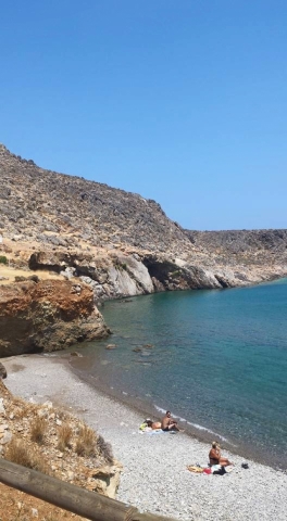

Karoumes Beach (or Chohlakies Beach): At the village Chohlakies begins a magnificent accessible Karoumes gorge that ends after 1,5 hour walking to the pure and scenic bay of Karoumes. Chochlakies village is located between Palekastro and Zakros.
You can approach this completely lonely beach only through this gorge! Karoumes is the most remote beach in Eastern Crete !! Chohlakies is located 8 km south from Palekastro, on the way to Zakros.

This is the most famous gorge in the area, also known as the Canyon of the Dead, due to the Minoan cemetery. Apart from its impressive topography, rich flora and plentiful water, it is also home to several sites of archaeological and historical interest. The E4 path passes through the gorge, while at its exit there is an organized rock climbing area. The trail starts from Epano Zakros and ends at the archaeological site of Kato Zakros.


Between Palekastro and Zakros in east of Crete you can find lots of pretty villages with beautiful churches in a green surrounding. Azokeramos is one of them and it can be reached on the Sitia - Palekastro - Azokeramos - Zakros road. The distance from Sitia is about 30 kilometers.
At the entrance of the village there is the Byzantine church of Agios Ioannis. Together with a number of other small villages the village of Azokeramos lies in in a fertile valley that is surrounded by high mountains on all sides. In the village Azokeramos itself there is a nice big church in the shape of a cross. Next to the church stands the clock tower and it is surrounded by cypresses.
Here you have wonderful views over the valley which is filled with olive trees. A little deeper into the village there is another small church that consists of two houses with turrets at the back. At the front you can see the tower with the clock rise high above the church. The front also has three crosses. Also there are many crumbling old stone houses in the village.
Distances:Kellaria - Palekastro 9 kmKellaria - Sitia 26 kmKellaria - Heraklion Airport 158 kmKellaria - Kato Zakros 19 kmKellaria - Xerokampos 20 km
Kamares is a small hamlet at the beginning of Chochlakia gorge with characteristic local architecture.

Approximately half way along the path leading from Kato Zakros to Karoumes beach (geotrail 12) and near Pelekita cave, is the ancient quarry by the same name. We find it amidst compacted Pleistocene aeolianite sandstone, which were easily excavated as they are soft rocks due to their many pores. On the rocks in the area there are several traces of the excavation activity that took place in the past.
These are isolated limestone boulders that have come loose and rolled along part of the Kato Zakros – Karoumbes footpath. The boulders are spread out and impressive, and create a theatrical landsnappee, as though they are alive. They are also ideal for climbing (bouldering).


 Login with
Facebook
Login with
Facebook